


Satellite Imagery Reveals Extensive Monsoon Cloud Belt Across Asia
The CSR Journal Magazine

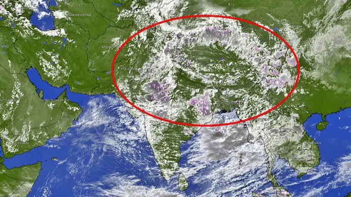
Recent satellite imagery has prominently shown a vast expanse of clouds stretching from northern India into Asia, indicating a robust monsoon pattern. This phenomenon is not merely one large storm but a prolonged zone characterised by deep convection and significant cloudiness, interspersed with numerous rain-bearing clusters and thunderstorms.

The cloud formation initiates in parts of Pakistan and northwest India, then extends across northern and central regions of India. The imagery continues as the cloud belt rises through the Himalayan region, ultimately reaching Nepal, Bhutan, Tibet, and China. This broad cloud shield can stretch for thousands of kilometres, with similar monsoon patterns observable across Asia potentially exceeding 5,000 kilometres as they progress eastward into China and the surrounding areas.

Implications of the Cloud Formation for Regional Weather

One of the distinctive features observed in the satellite imagery is the concentration of bright, cold cloud tops noted in infrared images. The presence of these cold cloud tops typically signifies that the clouds have achieved significant vertical growth, which is characteristic of deep convection. These towering clouds are capable of generating intense precipitation, thunderstorms, and lightning, which may lead to exceptionally heavy rainfall in certain areas.

This cloud formation is particularly significant as India is entering a crucial phase of the monsoon season. The India Meteorological Department has predicted widespread rainfall and thunderstorms across several regions, especially in northern India, following this recent development. It highlights how the monsoon system operates not as isolated weather patterns but rather as a cohesive entity that encourages moisture accumulation and rising air across a wide area.

The monsoon trough primarily functions as a conveyor belt for moisture, which along with embedded low-pressure areas, cyclonic circulations, and regional thunderstorms can amplify rainfall in various sections of the cloud belt. Observations indicate considerable cloud development over northern India and the Himalayan foothills, where the interaction of moist monsoon winds with the terrain further enhances the likelihood of increased rainfall.

Variability of Rainfall Associated with the Cloud Belt

Despite the extensive cloud coverage, it is important to note that not every area beneath this shield will experience continuous or uniform rainfall. The individual convective clusters can fluctuate in intensity and movement, resulting in scenarios where certain locations receive torrential rain, while neighbouring areas may experience significantly lesser amounts.

This recent satellite observation serves as an exemplary representation of an active monsoon phase across India. It illustrates the extensive atmospheric conveyor transporting moisture across the subcontinent en route to the Himalayas. The impressive scale of the cloud formation captured in the imagery further demonstrates that it transcends a mere localised rain cloud, instead forming part of a continental-scale monsoon circulation that spans thousands of kilometres across Asia.

As the monsoon season progresses, monitoring such significant cloud formations will be crucial for predicting rainfall patterns and their potential impacts on the region’s weather, agriculture, and water resources. The ongoing updates and forecasts from meteorological agencies will provide further insight into how this expansive cloud belt will influence weather conditions in India and beyond.

Long or Short, get news the way you like. No ads. No redirections. Download Newspin and Stay Alert, The CSR Journal Mobile app, for fast, crisp, clean updates!

App Store –  https://apps.apple.com/in/app/newspin/id6746449540 

Google Play Store – https://play.google.com/store/apps/details?id=com.inventifweb.newspin&pcampaignid=web_share

Latest News

Popular Videos
