


Monsoon Retreats From Delhi As Rainbelt Shifts Towards Himalayas
The CSR Journal Magazine

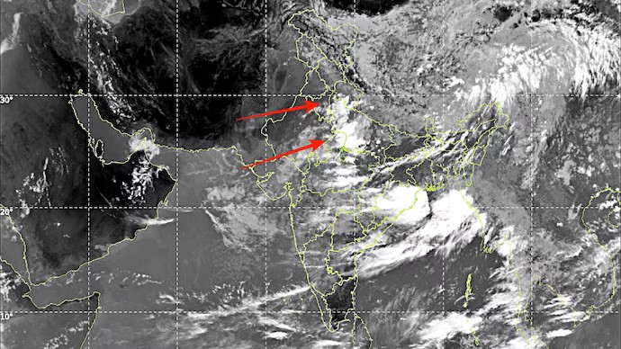
The monsoon is reportedly retreating from Delhi-NCR, Punjab, and Haryana, providing much-needed relief to residents following a stretch of humid and uncomfortable weather. The shift is attributed to dry northwesterly winds sweeping across northwest India, signalling a change in local climate patterns. Recent satellite imagery from INSAT-3DS, dated August 16, captures the notable concentration of monsoon activity primarily over eastern and central India, extending its influence from eastern Uttar Pradesh through Bihar and into the Bay of Bengal.

In contrast, many areas within Punjab, Haryana, and the Delhi-NCR region are currently experiencing relatively clear skies. Weather analysts indicate that persistently strong northwesterly winds, moving in at speeds exceeding 10 kmph, are contributing to the influx of drier air. Although daytime temperatures are not anticipated to drop significantly, the decline in moisture levels is expected to result in lower humidity, thereby enhancing comfort for residents.

The apparent shift in weather conditions is likely to improve the real-feel temperature as dry winds replace the previously dominant moisture-laden monsoon airflow. The forecast for the next two days suggests a prolonged period of dry weather, with only isolated evening showers predicted in select areas. No widespread rainfall is anticipated across Delhi-NCR, Punjab, and Haryana until at least August 17.

Monsoon Trough Movement Influences Rainfall Patterns

The alteration of the monsoon trough towards the Himalayan foothills is expected to contribute to increased rainfall in parts of Himachal Pradesh and Uttarakhand, along with adjacent areas. This regional shift results in a pronounced change in the distribution of rainfall across northern India. While the residents of Delhi and nearby states enjoy a brief reprieve from the sticky humidity characterising the monsoon season, the situation is not expected to remain static for long.

Forecast models suggest a potential transformation in weather patterns between August 18 and August 20, as a low-pressure system is expected to move inland from the Bay of Bengal. This incoming weather system is likely to influence the monsoon trough, prompting it to oscillate southward again. Consequently, rainfall activity might gradually re-emerge in northwest India as the week progresses, particularly during the weekend.

The anticipated low-pressure system is also projected to concentrate significant rainfall across eastern and central areas of Uttar Pradesh, as well as Bihar, Jharkhand and parts of Madhya Pradesh. Residents in these regions should prepare for heavy downpours in the days following, even as Delhi and its adjoining states temporarily enjoy clearer atmospheres.

Residents Await Further Weather Developments

For the moment, inhabitants of Delhi-NCR and the surrounding states can expect a welcome break from the high humidity and damp conditions associated with the monsoon. The improved weather, characterised by clearer skies and lower humidity, is set to provide greater comfort until further rain patterns affect the region. Local meteorological agencies continue to monitor the developments closely to inform residents of any significant changes in weather patterns forthcoming in the near future.

In summary, while a short-lived respite from the monsoon’s challenges is occurring, shifts in weather are likely to bring further rain to the northwest, necessitating ongoing observation and readiness for potential changes that could impact daily life.

Long or Short, get news the way you like. No ads. No redirections. Download Newspin and Stay Alert, The CSR Journal Mobile app, for fast, crisp, clean updates!

App Store –  https://apps.apple.com/in/app/newspin/id6746449540 

Google Play Store – https://play.google.com/store/apps/details?id=com.inventifweb.newspin&pcampaignid=web_share

Latest News

Popular Videos
