


Heavy Rain Expected as Satellite Imagery Reveals Cloud Surge and Yellow Alert Issued
The CSR Journal Magazine

The India Meteorological Department (IMD) has issued a yellow alert, indicating potential rain, thunderstorms, and gusty winds across several Himalayan states. This advisory comes as a significant weather system approaches from the west, leading to unstable weather conditions in the region. The IMD’s alert highlights the need for preparedness as this weather phenomenon unfolds.

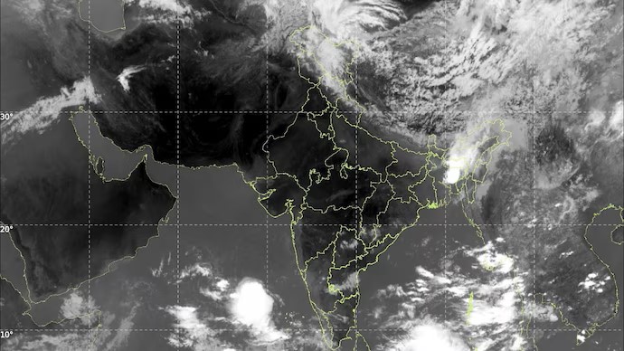
A large western disturbance is currently affecting northern India, and its impact is evident in the latest satellite imagery from INSAT-3DS. The thermal infrared images reveal a prominent spiral cloud formation, extending across Jammu & Kashmir, Himachal Pradesh, and Uttarakhand. These patterns indicate that the weather system is becoming increasingly active, which could result in various severe weather events.

Dense and cold cloud tops are visible over the western Himalayas, marking the presence of an active western disturbance interacting with warm pre-monsoon air over the region. This interaction is critical, as it creates conditions conducive for thunderstorms and heavy rainfall.

Heavy Rainfall Likely in Southern India

In addition to the situation in the north, a separate weather pattern is developing over southern India. Reports indicate that large clusters of deep convective clouds are rapidly forming over the Arabian Sea, particularly near Kerala and the Lakshadweep Islands. This intensification hints at the strengthening of monsoon activity in the region.

The satellite imagery supports this analysis, showing a build-up of thick cloud bands in the area southwest of Kerala. These clouds suggest an influx of moisture from the equatorial Indian Ocean, which is a positive sign for the impending arrival of the southwest monsoon. The IMD has noted that the onset of the monsoon is likely to occur around May 26, ahead of the usual date of June 1.

Meteorologists have indicated that if the monsoon arrives as forecasted, it will be one of the earlier entries in recent years. The presence of intense thunderstorms developing over the southeast Arabian Sea further reinforces this prediction, as meteorologists look for specific atmospheric signals to confirm the monsoon’s arrival.

Impact of Current Weather Conditions

As the monsoon approaches, the IMD has warned of isolated heavy to very heavy rainfall across parts of Kerala between May 28 and June 3. This increase in rainfall is typical during the initial phases of monsoon onset when significant amounts of moisture begin to penetrate inland.

At the same time, central and northwest India are experiencing severe heatwave conditions. The clash between the intensely hot and dry continental air and the incoming moist weather systems is contributing to the development of violent thunderstorms in northern India. This atmospheric interplay is crucial in determining the overall weather dynamics in the upcoming days.

The satellite imagery captures this contrast vividly: while dry air prevails over central India, significant cloud formations are visible over both the Himalayas and the Arabian Sea. This dual phenomenon exemplifies the nation’s transition from peak summer conditions to the onset of the monsoon season, signalling a critical time for weather patterns across India.

Long or Short, get news the way you like. No ads. No redirections. Download Newspin and Stay Alert, The CSR Journal Mobile app, for fast, crisp, clean updates!

App Store –  https://apps.apple.com/in/app/newspin/id6746449540 

Google Play Store – https://play.google.com/store/apps/details?id=com.inventifweb.newspin&pcampaignid=web_share

Latest News

Popular Videos
