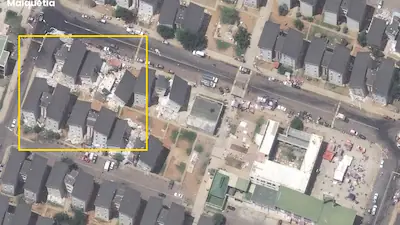
Nasa Satellite Scan Identifies 58,870 Buildings Affected by Venezuela’s Twin Earthquakes

The CSR Journal Magazine

The twin earthquakes that struck Venezuela recently resulted in significant damage, affecting over 58,000 buildings. This information comes from a preliminary assessment using satellite data released by NASA. The earthquakes, measuring magnitudes of 7.2 and 7.5, are reported to be the strongest to hit the country in over a century.

According to preliminary findings, approximately 1,700 individuals lost their lives, while thousands remain missing after the seismic events. These startling statistics highlight the scale of the disaster and the urgent need for recovery efforts.

Researchers Corey Scher and Jamon Van Den Hoek from Oregon State University have evaluated satellite radar data gathered on June 25, the day following the earthquakes. They noted that the assessment indicates substantial changes to the earth’s surface that align with noted structural damage.

Satellite Data Assessment and Findings

The NASA report indicates that about 58,870 buildings across the affected area are likely damaged or destroyed. This figure is based on data from the European Space Agency’s Sentinel-1 high-resolution radar imagery satellite. Scher and Van Den Hoek emphasised that the assessment is preliminary and should be viewed as a mere indicator of potential damage, not as a fully verified account.

National Assembly President Jorge Rodriguez, addressing the impact of the quake, stated that 855 buildings have been officially reported as damaged. This includes 189 buildings that have experienced total collapse. Such reports underscore the immediate impacts felt by local communities.

NASA’s involvement extends beyond preliminary assessments as its satellites are actively providing critical imagery and data. These resources aim to assist ground teams in evaluating the effects of the earthquakes and in planning appropriate response actions.

Ongoing Response and Recovery Efforts

The situation on the ground remains fluid, with recovery efforts in various stages of development. Teams are working to assess the full extent of the damage and to locate missing individuals. The preliminary satellite data will be crucial in guiding the initial phases of recovery.

Local authorities and international teams are collaborating to manage the crisis, focusing on the safety and well-being of affected populations. The combined efforts are vital to ensuring that timely aid reaches those in need and that reconstruction can begin as soon as possible.

As recovery efforts continue, there is an ongoing need for resources and support to assist the survivors. The insights provided by satellite assessments play a pivotal role in shaping the response strategies for the dispossessed individuals and communities across Venezuela.

Long or Short, get news the way you like. No ads. No redirections. Download Newspin and Stay Alert, The CSR Journal Mobile app, for fast, crisp, clean updates!

App Store –  https://apps.apple.com/in/app/newspin/id6746449540 

Google Play Store – https://play.google.com/store/apps/details?id=com.inventifweb.newspin&pcampaignid=web_share

Latest News

Popular Videos