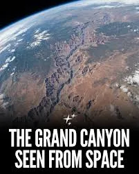
The Grand Canyon, located in Arizona, USA, is a breathtaking geological feature that has captured human imagination for centuries. Recent scientific research has shed light on its age and formation process, revealing significant details about the Colorado River’s journey and the geological changes over millions of years. A study published in the journal Science provides crucial insights into the Grand Canyon’s history through the analysis of microscopic mineral grains.
Approximately 6.6 million years ago, the Colorado River began to flow into a substantial natural depression in northeastern Arizona, described as a giant bowl carved into the Earth. This geological formation filled with water over time, leading to the emergence of Bidahochi Lake, an expansive and shallow body of water covering more than 150 kilometres. This lake was primarily situated within what is now the Navajo Nation reservation.
The river has been actively sculpting rock in Arizona for around five million years, giving rise to one of the most dramatic landscapes on Earth. The transformation of the landscape reflects a dynamic history of erosion and sediment deposition, culminating in the Grand Canyon as seen today.
Research Methods to Establish the Canyon’s Age
Researchers employed microscopic zircon grains, found within sandstone rock, to help date aspects of the Grand Canyon’s formation. These tiny crystals act as geological time capsules, containing crucial information about their origin and formation dates. By meticulously analysing hundreds of thousands of these zircon grains across various rock layers, scientists have reconstructed the ancient course of the Colorado River with notable accuracy.
Additionally, the team examined minute particles of volcanic ash embedded within the rock layers. As volcanic eruptions are precisely dated using established scientific techniques, this ash provides a timeline for when specific sand layers were deposited, offering insights into the river’s path during various geological periods.
Approximately 5.6 million years ago, Bidahochi Lake overflowed, triggering the rapid flow of the Colorado River through the region that eventually became the Grand Canyon, akin to an overflowing bathtub but on an enormous geological scale. This overflow initiated the river’s continued journey downstream, leading to significant landscape alterations.