


Monsoon Revival Anticipated as Satellite Imagery Indicates Significant Weather Changes
The CSR Journal Magazine

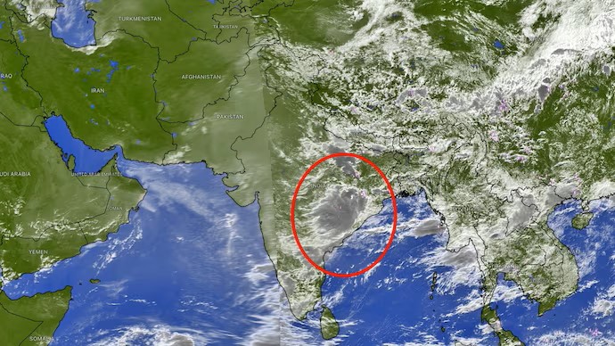
The latest satellite imagery indicates a promising resurgence of the southwest monsoon, which has been relatively inactive for nearly a week. Observations from INSAT-3DR and various international weather satellites reveal a robust low-pressure system developing over the northwest Bay of Bengal. This system is marked by dense convective cloud bands that extend across regions including Odisha, West Bengal, and parts of eastern India.

Experts in meteorology suggest that the eastward movement of the monsoon trough, along with this low-pressure system, is expected to trigger significant rainfall activity across northern India starting this weekend. The satellite images depict towering thunderstorm clouds associated with the low-pressure area as it progresses inland from the Bay of Bengal.

As this system moves northwestward, it is anticipated to transport large quantities of moisture into the Indo-Gangetic plains and central India, setting the stage for widespread rainfall in the coming days.

Heavy Rainfall Expected in Multiple States

The initial phase of the monsoon revival is projected to bring substantial rainfall to states such as Odisha, Gangetic West Bengal, Jharkhand, and eastern Uttar Pradesh. Preliminary forecasts indicate that Uttar Pradesh and Uttarakhand may experience pervasive heavy rainfall beginning on Saturday, with conditions extending into Punjab, Chandigarh, Delhi, Haryana, and eastern Rajasthan from Sunday through Monday.

Weather models predict that the timeframe from July 19 to July 25 could represent one of the most active phases of the monsoon season for northern India. Rainfall accumulation during this period is expected to be considerably high across various states.

Uttarakhand is predicted to receive between 300-500 mm of rain over the week, while Uttar Pradesh could see rainfall totals ranging from 200-350 mm. Himachal Pradesh and Jammu are forecast to experience 150-300 mm, with Punjab and Chandigarh likely to receive 100-200 mm. In the Delhi-National Capital Region and Haryana, expected rainfall amounts may reach between 100 and 150 mm, while eastern Rajasthan could see totals of 75-200 mm.

Risks Associated with the Anticipated Rainfall

The anticipated revival of monsoon conditions is positive for agricultural activities, particularly as the weakened monsoon earlier had delayed kharif sowing and exacerbated rainfall deficits in several regions. A consistent period of rainfall could enhance soil moisture, boost reservoir levels, and mitigate seasonal rainfall deficits across northern and central India.

However, this pronounced revival also raises concerns regarding hazardous weather, particularly in the Himalayan region. Meteorologists have warned that intense rainfall combined with already saturated mountain slopes could heighten the risks of landslides, flash floods, and isolated cloudbursts, specifically in Uttarakhand and Himachal Pradesh.

Individuals planning to travel to the hill states during the weekend and early next week are advised to stay informed about weather updates and exercise caution. If the forecasts accurately materialise, the upcoming week may herald a significant turnaround for the monsoon season, effectively concluding the dry spell and reinstating widespread rainfall across extensive areas of northern India.

Long or Short, get news the way you like. No ads. No redirections. Download Newspin and Stay Alert, The CSR Journal Mobile app, for fast, crisp, clean updates!

App Store –  https://apps.apple.com/in/app/newspin/id6746449540 

Google Play Store – https://play.google.com/store/apps/details?id=com.inventifweb.newspin&pcampaignid=web_share

Latest News

Popular Videos
