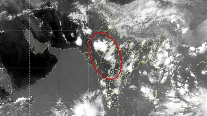
Massive 1,600-Km-Long Thunderstorm Captured from Jodhpur to Hyderabad

The CSR Journal Magazine

A significant band of thunderstorms extending approximately 1,600 kilometres across India was documented by the India Meteorological Department’s (IMD) INSAT-3DS satellite on Monday evening. This phenomenon underscores the remarkable scale of pre-monsoon weather developments affecting the country. The satellite image reveals a largely uninterrupted corridor of towering thunderclouds starting from western Rajasthan, near Jodhpur, and advancing through central India down to Telangana and Hyderabad.

This expansive mass of clouds is part of a larger weather system that has enveloped a substantial portion of the Indian subcontinent. Meteorologists report that roughly 70 to 80 per cent of the region is currently experiencing some form of thunderstorm activity or pre-monsoon cloud formation.

The imagery highlights dense cloud clusters over states including Rajasthan, Madhya Pradesh, Maharashtra, Telangana, Chhattisgarh, Odisha, West Bengal, Jharkhand, as well as parts of southern India. In addition, another extensive cloud formation is visible over the Himalayan region. Active weather systems are also present over Pakistan, Afghanistan, and adjacent areas, influenced by western disturbances affecting northern India for several weeks.

Impact on Temperatures and Weather Conditions

The abundance of moisture from the Arabian Sea and Bay of Bengal is facilitating thunderstorm development across central and peninsular India. As a result, there has been a notable reduction in daytime temperatures for many regions in the country. Areas previously subjected to severe heatwave conditions have seen a significant drop in maximum temperatures due to the continuous cloud cover, rainfall, and strong winds.

Widespread thunderstorm activity has effectively moderated extreme heat across several parts of northwestern, central, and eastern India. Weather experts are observing that the extensive thunderstorm corridor indicates strong atmospheric instability, combining warm surface temperatures, plentiful moisture, and suitable upper-level winds to create large clusters capable of generating heavy rainfall, lightning, strong winds, and localized hailstorms.

Numerous states have reported rainfall and thunderstorms in the last 24 hours, which have alleviated some heat while also causing disruptions from lightning strikes, waterlogging, and intense wind gusts. This widespread nature of cloud cover suggests that atmospheric conditions are becoming increasingly conducive to the impending arrival of the southwest monsoon.

Implications for the Upcoming Monsoon Season

The progress of the monsoon is under close observation. Current weather patterns indicate that large parts of India are already experiencing conditions typically associated with the transition from summer to the rainy season. This shift is evident as the region prepares for the monsoon season, which is crucial for agriculture and water resources.

As the satellite image captures a nation enveloped in clouds, it visually represents a significant weather event, with a singular thunderstorm belt stretching from Rajasthan to Telangana dominating much of the subcontinent. This meteorological activity serves as both a sign of impending seasonal changes and a reminder of the dynamic nature of weather systems affecting India.

Overall, the current thunderstorm activity marks an important phase for the Indian meteorological landscape, bringing with it both relief from excessive heat and noteworthy challenges associated with severe weather phenomena.

Long or Short, get news the way you like. No ads. No redirections. Download Newspin and Stay Alert, The CSR Journal Mobile app, for fast, crisp, clean updates!

App Store –  https://apps.apple.com/in/app/newspin/id6746449540 

Google Play Store – https://play.google.com/store/apps/details?id=com.inventifweb.newspin&pcampaignid=web_share

Latest News

Popular Videos