


Massive Cloud Band Approaching India Signals Upcoming Rainfall
The CSR Journal Magazine

Northern India is currently experiencing intense heat, with temperatures soaring as residents marked Eid on 27 May 2026. Sri Ganganagar in Rajasthan recorded an alarming high of 48.2 degrees Celsius, reportedly the highest in the world for that day. As the region endures this heatwave, indications suggest that a change in weather is imminent.

Satellite Imagery Reveals Expansive Cloud Formation

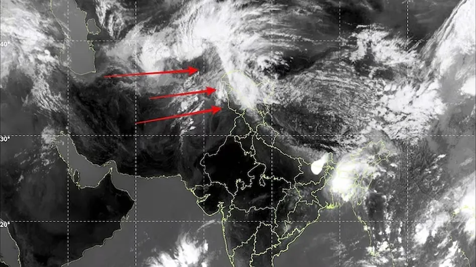
A significant cloud band, stretching approximately 2,500 kilometres, has been identified in thermal infrared imagery captured by India’s INSAT-3DS weather satellite. This extensive formation extends from Pakistan and northwest India, covering Punjab, Haryana, Delhi, Uttar Pradesh, and parts of central India, before merging into clusters over eastern India and the Bay of Bengal.

Meteorologists are analysing this cloud structure, which appears to result from a combination of a western disturbance and moisture from both the Arabian Sea and the Bay of Bengal. The satellite image highlights extremely cold cloud tops, indicated by bright white regions, suggesting the potential for intense thunderstorm activity in the coming days.

The presence of towering thunderstorm systems, often associated with heavy rainfall, thunderstorms, hailstorms, and strong winds, is anticipated. The imagery also identifies a distinct cyclonic circulation over northern Pakistan and Jammu and Kashmir, which is related to the active western disturbance moving through the western Himalayas. As moisture accumulates, widespread cloud formation is occurring over the Indo-Gangetic plains.

Forecast of Enhanced Weather Activity

Weather experts report that the current cloud structure indicates substantial atmospheric instability across northern India. This follows a prolonged period of extreme heat in Rajasthan, Delhi, Haryana, and other central regions. The convergence of hot surface temperatures with incoming moisture is likely to facilitate rapid thunderstorm development during the pre-monsoon transition.

Over the coming days, forecasters predict that various parts of northern India will experience increased weather activity, including thunderstorms, lightning strikes, dust storms, and scattered rainfall. The predicted rainfall will be significant, as the region prepares for the impact of the changing weather systems.

In addition to northern plains, the mountain states of Himachal Pradesh, Uttarakhand, and Jammu and Kashmir are also expected to receive moderate to heavy rainfall due to the influence of the western disturbance. As the southwest monsoon gradually advances from the southern seas surrounding India, this heightened cloud activity suggests an earlier-than-anticipated moisture influx into northern India.

Long or Short, get news the way you like. No ads. No redirections. Download Newspin and Stay Alert, The CSR Journal Mobile app, for fast, crisp, clean updates!

App Store –  https://apps.apple.com/in/app/newspin/id6746449540 

Google Play Store – https://play.google.com/store/apps/details?id=com.inventifweb.newspin&pcampaignid=web_share

Latest News

Popular Videos
