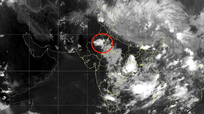
Powerful Storm System Approaches Delhi-NCR Bringing Heavy Rain

The CSR Journal Magazine

Delhi-NCR is preparing for a substantial shift in weather conditions as a robust storm system approaches the region, scheduled to arrive on Monday. Following several days of extreme heat and humidity, this weather change is expected to offer considerable relief.

Meteorologists have indicated that between 3 pm and 5 pm, areas such as Delhi, Noida, Gurugram, Ghaziabad, and Faridabad could experience dust storms with wind speeds ranging from 60 to 90 kmph. This initial dust storm may be followed by thunderstorms and moderate to heavy rainfall.

The forecast suggests that the most intense rainfall phase may persist for about 30 to 50 minutes, with certain regions likely to see brief bursts of heavy downpours. Gusty winds of 50 to 70 kmph, along with lightning activity, pose risks of reduced visibility, traffic disruptions, and occasional power outages.

Authorities Advise Caution During Storm Conditions

In light of potential hazards, authorities recommend that residents avoid outdoor activities during the storm’s peak hours. The combination of fierce winds and blowing dust may create dangerous situations for drivers, cyclists, and pedestrians. Furthermore, individuals are urged to steer clear of trees, electricity poles, and any temporary structures that might be susceptible to strong gusts.

This weather phenomenon is not restricted solely to Delhi-NCR. Nearby areas, particularly in Haryana, western Uttar Pradesh, and adjacent regions of Rajasthan, are also forecasted to experience similar conditions within the next few hours. Locations under alert include Sonipat, Rohtak, Jhajjar, Rewari, Mahendragarh, Hisar, Bhiwani, Charkhi Dadri, and Fatehabad in Haryana, alongside Bagpat and Khekra in Uttar Pradesh and Pilani, Bhiwadi, Sadulpur, and Sidhmukh in Rajasthan.

These regions are likely to witness similar dust storms, followed by thunderstorms that may produce lightning and varying rainfall levels from light to moderate. The advisory indicates a widespread impact across the affected territories.

Underlying Meteorological Factors Explained

Meteorologists attribute the approaching storm system to an interaction between hot, dry air over northwest India and moisture-laden winds moving inward. Such atmospheric dynamics are known to instigate pre-monsoon thunderstorms across the Indo-Gangetic plains.

Although the forthcoming storms may lead to temporary disruptions, they are anticipated to significantly reduce temperatures and enhance air quality throughout the region. This weather relief is expected to be welcomed by residents who have been enduring the oppressively hot summer conditions.

The radar images indicate a formation of rain clouds heading towards the Delhi-NCR zone, affirming predictions for upcoming weather changes. People are advised to remain vigilant as the situation develops, ensuring they take necessary precautions for safety during the storm events.

Long or Short, get news the way you like. No ads. No redirections. Download Newspin and Stay Alert, The CSR Journal Mobile app, for fast, crisp, clean updates!

App Store –  https://apps.apple.com/in/app/newspin/id6746449540 

Google Play Store – https://play.google.com/store/apps/details?id=com.inventifweb.newspin&pcampaignid=web_share

Latest News

Popular Videos