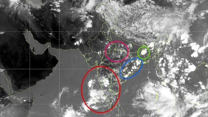
Massive Rain Clouds Observed Over India as Monsoon Approaches

The CSR Journal Magazine

The southwest monsoon is anticipated to arrive soon, as recent satellite images indicate the formation of rain-bearing clouds over India. The INSAT-3DS weather satellite captured imagery on June 3, 2026, showing an increase in cloud cover across extensive regions of the country, from the Himalayas to the southern peninsula. This development suggests a shift towards a more active atmospheric state as the monsoon prepares to take hold.

One striking feature in the satellite images is the considerable area of cloud stretching through northern India and into adjacent Pakistan. Dense formations of thunderstorm clouds were detected over Jammu & Kashmir, Himachal Pradesh, and Uttarakhand, while storm activity showed a scattered presence in Punjab, Haryana, and Uttar Pradesh.

Eastern India also experienced notable cloud build-up, with large clusters of thunderstorms visible from Odisha to West Bengal and extending into the northeastern states. The moisture influx from the Bay of Bengal continues to sustain daily rainfall and accompanying lightning, enhancing the region’s weather dynamics.

Monitoring Developments Over Southern India

In the southern part of the country, meteorologists are observing key developments near Kerala. Satellite data shows expanding cloud formations over the southeastern Arabian Sea and along India’s southwest coast. A mid-level cyclonic circulation is reportedly aiding in drawing moisture further inland, a process that is expected to boost rainfall in Kerala and coastal Karnataka in the coming days.

This cyclonic activity is predicted to create conditions that are conducive to the onset of the southwest monsoon in these areas. Weather experts are keeping a close eye on these developments, as the expected increase in rainfall could provide a significant respite from the dry conditions currently being experienced.

Additionally, images indicate substantial cloud formation over the eastern Bay of Bengal and the Andaman Sea. These tropical cloud systems play a crucial role in enhancing the overall monsoon circulation, which eventually leads to widespread rainfall across the Indian subcontinent.

Expectations for Rainfall and Thunderstorm Activity

The rise in cloud cover follows a period of widespread thunderstorms in northern, central, and eastern India, which provided temporary relief from the intense summer heat. Many regions recorded significant drops in temperature, accompanied by thunderstorms, brisk winds, and rainfall.

Looking ahead, meteorological forecasts suggest that thunderstorm activity will persist across much of India. Increased rainfall is anticipated over Kerala, Karnataka, and sections of Tamil Nadu. If the current atmospheric trends remain consistent, forecasters predict that the southwest monsoon may officially establish itself over Kerala by June 4.

In summary, the satellite imagery clearly depicts a transformation occurring in the atmosphere. After an extended period of anticipation, the first indications of India’s rainy season are materialising, promising a shift in weather patterns across the region.

Long or Short, get news the way you like. No ads. No redirections. Download Newspin and Stay Alert, The CSR Journal Mobile app, for fast, crisp, clean updates!

App Store –  https://apps.apple.com/in/app/newspin/id6746449540 

Google Play Store – https://play.google.com/store/apps/details?id=com.inventifweb.newspin&pcampaignid=web_share

Latest News

Popular Videos