


ISRO Satellite Reveals Large Vortex over Arabian Sea Enhancing Monsoon Rain in Gujarat
The CSR Journal Magazine

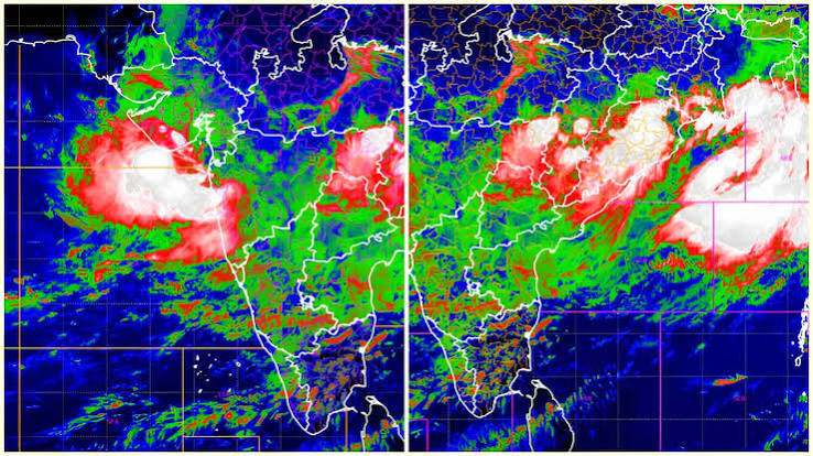
Recent observations from the Indian Space Research Organisation’s INSAT-3DR weather satellite have highlighted a significant atmospheric vortex rotating over the Arabian Sea. This phenomenon is reportedly responsible for the substantial monsoon rains currently affecting large regions of Gujarat. The satellite’s latest visible and thermal infrared images display a broad cyclonic circulation, which extends from the northeastern Arabian Sea into Gujarat, characterised by tightly wound cloud formations that consistently transport moisture inland.

This weather system has consequently turned the Arabian Sea into a virtual conveyor belt of moisture. As a result, persistent thunderstorms and extreme rainfall have been recorded across the state, creating challenges for local residents and authorities alike. Gujarat is currently experiencing one of the most intense monsoon phases of the season, markedly impacting daily life in the region.

In Ahmedabad, the city has recorded an impressive 294.6 mm of rainfall in a 24-hour period, concluding at 8:30 am on Friday. This figure marks the highest July daily rainfall recorded in the city this century and ranks as the fourth-highest daily total observed historically.

Understanding the Arabian Sea Vortex

Meteorologists have identified the vortex as an expansive atmospheric pump that generates counter-clockwise winds. These winds are drawing significant volumes of warm, moisture-loaded air from the Arabian Sea into Gujarat, where the air rapidly ascends. This upward movement facilitates the formation of towering thunderclouds capable of producing intense rainfall.

The infrared satellite images depict extremely cold cloud tops over northern and central Gujarat, illustrating the presence of deep convective storms that extend high into the atmosphere. Such cloud formations are frequently linked with severe thunderstorms, lightning, and notably heavy rain, contributing to the current weather patterns.

The prevailing weather system has exhibited an unusual tendency to remain slow-moving. This stagnation allows successive rain bands to repeatedly pass over the same areas, a phenomenon referred to as “training” thunderstorms. This occurrence can lead to significantly increased rainfall totals and raises concerns about flash floods and urban flooding within the affected districts.

Forecast and Alerts for Affected Areas

Forecast models suggest that the vortex will continue to influence weather patterns in western India for the next 24 to 36 hours. Heavy to extremely heavy rainfall is anticipated in several parts of Gujarat, as well as regions in southern Rajasthan and adjacent areas. In response to the predicted conditions, the India Meteorological Department has issued a red alert for various districts, cautioning residents regarding the potential for flooding, waterlogging, transportation disruptions, and overflowing rivers.

While the active monsoon conditions have reportedly contributed to alleviating seasonal rainfall deficits in various regions of the country, the ongoing situation in Gujarat underscores the capacity of a single moisture-rich vortex over the Arabian Sea to unleash extraordinary rainfall within a short timeframe.

The Arabian Sea has emerged as a central factor behind one of the most significant monsoon surges this season, with the powerful vortex continuing to channel rain-producing clouds towards Gujarat. As conditions are expected to gradually diminish in the coming days, authorities remain vigilant regarding the developments of this weather system.

Long or Short, get news the way you like. No ads. No redirections. Download Newspin and Stay Alert, The CSR Journal Mobile app, for fast, crisp, clean updates!

App Store –  https://apps.apple.com/in/app/newspin/id6746449540 

Google Play Store – https://play.google.com/store/apps/details?id=com.inventifweb.newspin&pcampaignid=web_share

Latest News

Popular Videos
