


India Backs UN Resolution Seeking More Accurate Representation Of World Map
The CSR Journal Magazine

India has voted in favour of a United Nations General Assembly resolution seeking to promote a more accurate representation of the world’s continental landmasses on maps. The 193-member Assembly adopted the resolution on Friday with 164 countries voting in favour, six abstaining and the United States voting against it.

Sponsored by Togo, the resolution argues that widely used world maps distort the apparent size of regions located far north and south of the equator. It says such distortions have contributed to minimising the perceived size of Africa, Latin America and South Asia and have reinforced an imbalanced understanding of the world.

UN Resolution Challenges Long-Used Map Projection

Titled “Correct the map”: rebalancing global cartographic representation and promoting equitable representation of the world’s regions, particularly Africa, the resolution highlights concerns over the continued use of projections that inaccurately portray the relative size of continents.

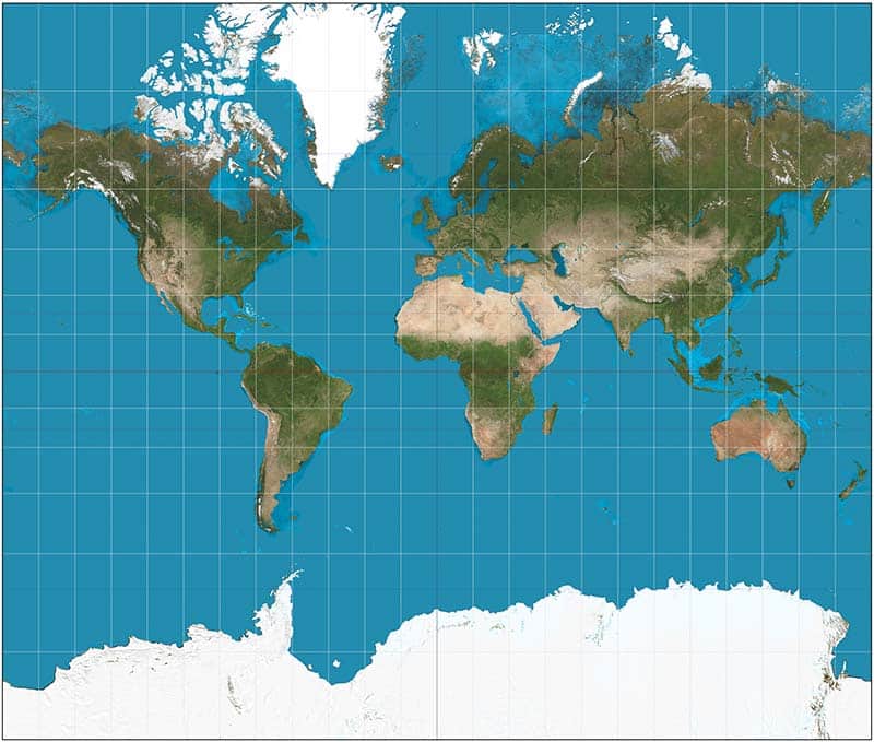
It specifically refers to the Mercator projection, developed in the 16th century primarily for navigation. Despite the distortions associated with representing the Earth’s curved surface on a flat map, the projection continues to be widely used in educational materials, media, digital platforms and official documents.

The resolution argues that landmasses located farther from the equator appear disproportionately large under the Mercator projection. This has implications for how people perceive the relative size and geographical importance of different parts of the world.

Six countries abstained during the vote: Estonia, Georgia, Lithuania, Moldova, Serbia and Ukraine. The United States was the only country to vote against the resolution.

India Supports Fairer Cartographic Representation

Explaining India’s position, Raghoo Puri, First Secretary at India’s Permanent Mission to the UN, said New Delhi welcomed the objective of encouraging more accurate and representative approaches to map-making.

“We believe that maps play an important role in how societies understand geography and the relative scale of the world around us,” Puri said.

India, however, made clear that its support did not amount to an endorsement of one particular map projection. Puri said New Delhi viewed the resolution as encouraging broader consideration of Equal Area map projections.

“We believe that the resolution should be understood as supporting the broader use and consideration of Equal Area map projections, and not as endorsing the Equal Earth projection or any other specific map projection,” Puri said.

India Draws Line On Specific Map Projection

Equal Area projections are designed to preserve the relative areas of geographical regions, addressing one of the major limitations associated with projections such as Mercator. India’s position was that the UN resolution should encourage consideration of such approaches rather than prescribe a particular projection.

By voting for the resolution, India therefore supported the broader objective of improving the fairness and accuracy of global cartographic representation while maintaining that the text should not be interpreted as backing the Equal Earth projection or any other individual map design.

The overwhelming vote in favour reflects growing attention at the international level to how cartographic choices can shape perceptions of the relative scale of different regions. The resolution specifically places emphasis on improving the representation of Africa and other regions whose apparent size can be significantly affected by conventional world maps.

Long or Short, get news the way you like. No ads. No redirections. Download Newspin and Stay Alert, The CSR Journal Mobile app, for fast, crisp, clean updates!

App Store –  https://apps.apple.com/in/app/newspin/id6746449540 

Google Play Store – https://play.google.com/store/apps/details?id=com.inventifweb.newspin&pcampaignid=web_share

Latest News

Popular Videos
