


Heavy rainfall and thunderstorms are expected in South India and the Andaman Islands on Sunday
The CSR Journal Magazine

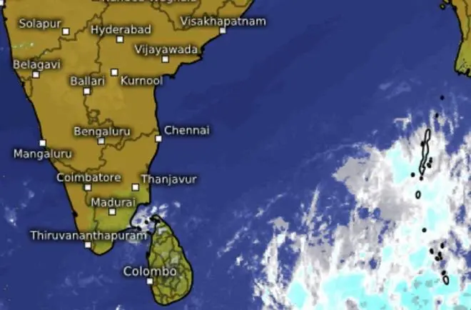
The India Meteorological Department (IMD) has indicated that on Sunday, September 20, various areas in South India and the Andaman & Nicobar Islands are anticipated to experience significant rainfall and thunderstorms. This forecast was provided on Saturday, September 19, and highlights the likelihood of isolated heavy precipitation across several states including Coastal Andhra Pradesh, Karnataka, Kerala, Tamil Nadu, Puducherry & Karaikal, and Telangana. Alongside heavy rain, thunderstorms with potential gusty winds reaching between 40 to 50 kmph are expected, suggesting sudden bursts of rain and strong winds during the day.

As residents prepare for the adverse weather conditions, it is essential for individuals to take precautions while moving outside. The potential for storms emphasises the need for awareness and readiness among the public to avoid any hazards posed by the weather.

Thunderstorms Impacting Central and Eastern India

In addition to the Southern states, thunderstorms with lower wind speeds of 30 to 40 kmph are forecasted for regions including East Rajasthan, Gangetic West Bengal, Jharkhand, Konkan & Goa, Madhya Pradesh, North Karnataka, Telangana, and Vidarbha. The Northeast is also likely to face thunderstorms and lightning, affecting areas such as Arunachal Pradesh, Assam, Meghalaya, and the Nagaland-Manipur-Mizoram-Tripura region. The potential for thunderstorms will extend to Chhattisgarh, Kerala, and Lakshadweep as well, although these regions are not expected to see the same level of wind strength as other areas.

Both Andhra Pradesh and Telangana are also forecasted to experience strong surface winds, which could exacerbate the thunderstorm conditions. Satellite imagery continues to monitor the evolving weather patterns over these territories as the situation develops.

Strengthening Weather System in the Bay of Bengal

An important weather system developing over the north Andaman Sea is likely to have significant implications in the following days. The IMD reported that this system, which formed into a low-pressure area on Friday, is projected to strengthen into a depression by September 21 and could develop into a deep depression by September 22 as it moves towards the coasts of Odisha and Andhra Pradesh. This system is expected to make landfall around September 23, potentially influencing rainfall across the eastern regions of India over the forthcoming week.

The IMD will continue to track this weather system closely, given its implications for tropical cyclone activity and rainfall variability across the eastern parts of the country.

Withdrawal of the Southwest Monsoon

Simultaneously, the southwest monsoon has begun its withdrawal from India. The IMD confirmed that the monsoon withdrew from certain areas of West Rajasthan on September 19, slightly later than its normal withdrawal date of September 17. Current conditions appear conducive for the monsoon to retreat further from areas within Rajasthan, Punjab, and Saurashtra & Kutch in the next three to four days.

As the monsoon withdrawal proceeds in the northwest, contrastingly, parts of Southern and Eastern India are preparing for another phase of heavy rain and thunderstorms as the weather system in the Bay of Bengal continues to strengthen. This shift emphasises the ongoing variability in weather patterns across different regions of the country.

Long or Short, get news the way you like. No ads. No redirections. Download Newspin and Stay Alert, The CSR Journal Mobile app, for fast, crisp, clean updates!

App Store –  https://apps.apple.com/in/app/newspin/id6746449540 

Google Play Store – https://play.google.com/store/apps/details?id=com.inventifweb.newspin&pcampaignid=web_share

Latest News

Popular Videos
