


Heavy Rainfall Expected Due to Monsoon System Over Bay of Bengal
The CSR Journal Magazine

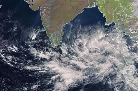
A powerful monsoon system developing over the Bay of Bengal is anticipated to bring very heavy rainfall to eastern and central India in the coming two days, according to the India Meteorological Department (IMD). Satellite imagery from INSAT-3DS revealed a large area of dense cloud cover over the Bay of Bengal and eastern India, indicating a depression situated over the northwestern Bay of Bengal and adjacent coasts of West Bengal and Odisha.

This weather system is predicted to enhance rainfall as it moves inland. Under its influence, heavy to very heavy rainfall is anticipated across Gangetic West Bengal, Odisha, Jharkhand, and Chhattisgarh until August 18. The IMD has also highlighted the possibility of isolated spells of extremely heavy rainfall in parts of Gangetic West Bengal, Odisha, and Chhattisgarh on August 17, with a shift towards Jharkhand on August 18.

Current Weather Conditions and Expected Impact

The satellite image shows significant convective cloud formations surrounding the depression, indicating a strong influx of moisture from the Bay of Bengal. Meteorologists assert that this system is drawing substantial moisture inland, thereby creating ideal conditions for intense thunderstorms. Several districts in Odisha and West Bengal have already recorded continued rainfall, with worsening conditions expected as the depression moves west-northwestward.

Authorities have raised concerns about potential waterlogging in low-lying areas, and rivers and streams may experience swift rises in their water levels as the system progresses. The renewed rainfall activity is likely to be beneficial for areas in eastern and central India that have previously faced deficits in monsoon rainfall; however, officials are closely monitoring the situation for risks related to localised flooding, landslides, and interruptions in road and rail traffic.

Additionally, the IMD noted that the Bay of Bengal has been particularly active this monsoon season, consistently generating successive weather systems that have contributed to widespread rainfall across India. The expected track of the depression indicates it will remain well-defined for the next 24 to 48 hours.

Precautions and Preparedness Advisory for Residents

Residents in the states affected by this weather pattern have been urged to stay updated with the latest weather forecasts and take precautions against the anticipated severe conditions. Preparations for intense rainfall, thunderstorms, and strong winds are advised to minimise any adverse impact. People living in vulnerable areas should remain alert, given the forecast of potential flooding and landslides.

The IMD continues to monitor the developing situation closely and will provide updates as new information becomes available. Such proactive measures are crucial to ensure public safety during this active phase of the monsoon, which is expected to bring both benefits and challenges to the region over the coming days.

The ongoing developments highlight the significance of staying informed and prepared during periods of extreme weather, as the implications can affect daily life and infrastructure. Authorities are focusing on effective communication to ensure that the public is aware of the risks and can take appropriate action in due course.

Long or Short, get news the way you like. No ads. No redirections. Download Newspin and Stay Alert, The CSR Journal Mobile app, for fast, crisp, clean updates!

App Store –  https://apps.apple.com/in/app/newspin/id6746449540 

Google Play Store – https://play.google.com/store/apps/details?id=com.inventifweb.newspin&pcampaignid=web_share

Latest News

Popular Videos
