Mumbai Is Nepal’s Future: Just With the Floods Coming From the Other Direction
The CSR Journal Magazine

On the morning of 26 August 2026, a stretch of the Trishuli River in central Nepal simply stopped behaving like a river. A section of the Langtang Lirung glacier, roughly 2,000 feet wide, sheared off and fell nearly 7,000 feet, according to satellite analysis reported by CNN. The impact and the debris it carried triggered a tremor measuring 5.2 that seismometer picked up worldwide, and unleashed a wall of water, rock and ice that tore through a 72 km corridor covering Rasuwa, Nuwakot, Dhading, Gorkha, Tanahun, Nawalparasi and Chitwan districts. It flattened the Gyirong Port complex, the main trade and tourism gateway between Nepal and China and carried bodies as far as 240 km into India.

By the end of August, Nepal’s Disaster Management Authority had confirmed 734 to 800 dead and roughly 2,500 to 3,000 missing, most of them believed buried under debris or swept downstream. Sixteen more died and over 500 were reported missing in Tibet’s Gyirong County on the Chinese side. Foreign ministries scrambled: India sent an 11-member tunnel rescue team, China sent its own, and even the White House offered help. Nepal’s foreign minister used the moment to call, publicly and pointedly, for a global crackdown on climate change.

That single line matters more than it might seem. A small, poor, landlocked country just lost close to a thousand citizens to a hazard it did not create and cannot mitigate alone. This is worth sitting with before moving to policy.

The science: this was not a monsoon flood

It is important to be precise about what this disaster was, because getting the mechanism wrong leads to the wrong prevention strategy. Nepal’s deadly floods of 2024 were driven by heavy monsoon rainfall hitting unplanned settlements on floodplains, a conventional hydrological disaster made worse by bad urban planning. The 2026 event was different in kind. It was very likely a Glacial Lake Outburst Flood, or GLOF, triggered by a sudden glacier collapse rather than by rainfall.

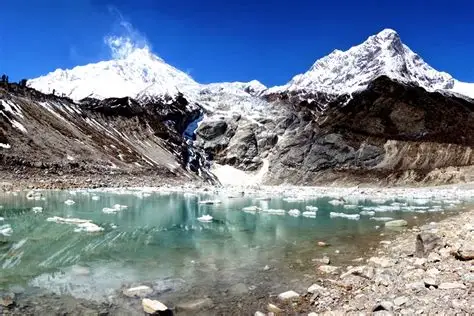
A GLOF happens when water trapped by a glacier or dammed behind a moraine of loose rock and ice, is released all at once, either because the dam fails, is overtopped, or because a rockfall or ice collapse displaces enough water to send it over the top. The International Centre for Integrated Mountain Development, ICIMOD, has mapped more than 25,000 glacial lakes across the Hindu Kush Himalaya region, and classifies over 200 of them as genuinely dangerous because they sit above populated valleys and major roads. Nepal alone has recorded more than 90 GLOFs since the 1920s, five of them in the Everest region.

This is not a new or speculative field of science. The 1985 Dig Tsho GLOF in the Khumbu Himal destroyed a nearly finished hydropower project. The 1994 Lugge Tsho GLOF in Bhutan is a standard case study in glaciology journals. The Kedarnath disaster in Uttarakhand in 2013 and the South Lhonak GLOF in Sikkim in 2023, which wiped out the Teesta III dam, are both well documented in Indian government reports. Researchers publishing in the Journal of Glaciology this year project a threefold increase in GLOF risk across the Himalaya by the end of the century as warming accelerates glacier retreat. A separate study of a glacial lake in Ladakh found it expanded by 78.7 percent over 22 years while its feeding glacier shrank by 13.2 percent in the same period. These are measured numbers, not projections built on assumption.

None of this means every GLOF is individually predictable to the day. Glacier collapses involve structural failure in ice under stress, and pinpointing the exact moment is genuinely hard. But knowing that a valley sits below a swelling, unstable lake, and that the frequency of these events is rising as the region warms, is not hard at all. That is a mapping and monitoring problem, and it has a known fix.

Could this have been prevented?

Partially, yes, and that is the uncomfortable part. ICIMOD’s own strategic framework for GLOF risk reduction lists the standard toolkit: hazard mapping of dangerous lakes, early warning systems with sensors and sirens tied to real-time monitoring, engineered interventions like controlled drainage channels and reinforced spillways to lower lake volumes before they become catastrophic, revised building codes for settlements in the flood path, and community-level evacuation drills. None of this is exotic. Nepal itself pioneered some of this after the 1985 Dig Tsho disaster, and again after the 2021 Melamchi flood, which should have been the wake-up call that pushed systematic monitoring across every major river basin fed by Himalayan glaciers.

It clearly did not happen at the scale needed. The Langtang Lirung sector had no early warning infrastructure that gave downstream communities meaningful notice. Settlements continued to grow along the Trishuli corridor. The Gyirong Port complex, a major cross-border trade facility, sat directly in the flood’s path with no protective works. This is a governance failure layered on top of a geological one. Glacier collapse is a natural hazard. A trade complex and dozens of villages sitting unprotected in its direct path, decades after the danger were documented, is a policy choice.

The transboundary dimension makes this worse. The glacier that failed straddles territory close to the China-Nepal border, and the flood hit both countries within minutes of each other, yet there is no binding, functioning joint monitoring system between Nepal, China and India for glacial lakes that threaten all three. ICIMOD has spent years trying to build exactly this kind of regional cooperation platform. It has never received the funding, political priority or cross-border data sharing needed to become an actual early warning network rather than a research body. Geopolitics between India and China, and the general caution both countries exercise around sharing data near sensitive border regions, has made this harder than it should be. A hazard that does not recognize the Line of Actual Control is being managed by institutions that very much do.

Bashing the ‘climate change deniers’, with numbers

There is still a strain of commentary, some of it from otherwise serious people, that treats any single disaster as too small a data point to say anything about climate change and treats the broader warming trend itself as unsettled or exaggerated. The data does not support that comfort. Long-term temperature records show an accelerating warming trend from around 1980 onward, after decades of relative stability and even some cooling in the 1960s and 70s. Glacier retreat across the Hindu Kush Himalaya is not a model projection, it is measured on the ground and from satellites, year after year, lake by lake. The Ladakh case above is one of dozens of similar studies showing the same pattern: lakes expanding, glaciers shrinking, and outburst risk climbing in step.

Sea level projections for Mumbai, discussed below, are not activist talking points either. They come from oceanographic and remote sensing research published in peer reviewed journals, using multiple emissions scenarios, and they converge on the same broad conclusion regardless of which model is used. When the mechanism is this well established and the on-ground measurements match the models this closely, treating climate change as a matter of opinion is not skepticism, it is simply ignoring the instruments. The people who pay for that gap in understanding are rarely the ones making policy from air-conditioned rooms. They are Himalayan villagers, Sikkimese dam workers, and Mumbai slum residents.

Where the global accords fall short?

The Paris Agreement set emissions targets but has no binding mechanism to fund glacial monitoring in Nepal or drainage upgrades in Mumbai. The Loss and Damage Fund agreed at COP28 was meant to address exactly this kind of harm, disasters that poor, low-emitting countries suffer because of a crisis they did not cause, but it remains chronically underfunded relative to even conservative damage estimates, and disbursement has been slow and bureaucratic. The Sendai Framework for Disaster Risk Reduction, the main global agreement on early warning systems and hazard mapping, is voluntary and has no enforcement teeth. Countries sign it, cite it in reports, and then fail to fund the monitoring stations it recommends.

This is the pattern worth naming plainly. Global climate governance has become very good at producing frameworks, communiqués and pledges, and much less good at putting sensors on glacial lakes or fixing storm drains. Nepal’s foreign minister asking for a global climate crackdown after burying hundreds of citizens is not rhetoric, it is a fair description of a system that keeps promising and keeps under-delivering.

Lessons for India

India does not need to imagine this scenario; it has already lived a version of it. The 2023 South Lhonak GLOF in Sikkim, triggered by a similar lake failure, destroyed the Teesta III dam and killed dozens. The 2013 Kedarnath disaster in Uttarakhand, though driven more by extreme rainfall than a glacier collapse, exposed the same pattern of unregulated construction in a known hazard zone. Studies of Ladakh and Jammu and Kashmir show glacial lakes there are expanding just as fast as in Nepal. India has the scientific capacity, through IIT Bombay, the Indian Institute of Tropical Meteorology and the Geological Survey of India, to run a serious glacial lake monitoring programme across its own Himalayan states. What it needs is sustained funding and a willingness to restrict hydropower and tourism development in mapped hazard zones, even when that is politically unpopular with state governments chasing revenue.

Lessons for Bhutan

Bhutan is smaller and more exposed than either neighbour. Its 1994 Lugge Tsho GLOF is one of the most cited case studies in the field precisely because the country’s glacial lakes sit close to its main population centres. Bhutan has comparatively strong environmental governance by regional standards, but a small state with a small budget cannot build a full monitoring network alone. Its safest path is deeper integration into a genuinely functional regional platform, most plausibly through ICIMOD, rather than depending on ad hoc bilateral goodwill from Delhi or Beijing.

Lessons for Mumbai, a different hazard with the same failure

Mumbai will not suffer a glacial lake outburst. Its danger is the opposite end of the same warming system: rising seas rather than melting mountains. Projections published in Scientific Reports show Mumbai and Kolkata facing the highest coastal flood risk among major Indian cities under high emissions scenarios, with sea level rise estimates of 24 to 66 centimetres by 2100 and a real possibility that the Arabian Sea floods parts of the city at least once a year by 2050. The city is also sinking, at roughly 2 millimetres annually according to IIT Bombay studies, which compounds every centimetre of sea level rise. A Nature-published study found that around 8 percent of monsoon deaths in Mumbai are rainfall related, and 80 percent of those deaths occur among people living in slums, with children under five and women facing the highest risk. Recent satellite flood mapping shows Chembur West, Matunga and Ghatkopar as the worst-hit wards.

The mechanism is different from Nepal’s. The governance failure is nearly identical. Mumbai has kept building on reclaimed land, encroaching on mangroves and salt pans that would otherwise absorb storm surge, much as Nepal kept building in glacial flood paths. The Brihanmumbai Municipal Corporation, one of the richest civic bodies in Asia, still runs a drainage network that studies say is decades out of date, while structural flood measures like emergency food supplies get more attention than the harder, less visible fix of upgrading storm drains and protecting natural buffers. Strengthening that drainage network alone, according to the city’s own climate risk analysis, could cut flood losses by more than 70 percent. That number should embarrass every civic budget meeting where drainage upgrades get deferred for another year.

The actual lesson

Glacial collapse in Rasuwa and rising tides in Mahim are not separate stories. Both are downstream consequences of the same warming trend, both were foreseeable in general terms decades in advance, and both were left to unregulated development and underfunded monitoring because prevention is expensive now and disasters are expensive later, and politics almost always prefers later. Nepal, India, Bhutan and coastal Indian cities like Mumbai are bound by the same rivers, the same monsoon system and increasingly the same climate risk. Treating disaster preparedness as a national afterthought rather than a funded, regional, scientifically driven priority is the one choice that keeps repeating across every one of these disasters, and it is the one choice fully within the control of governments, unlike the glacier itself.

Views of the author are personal and do not necessarily represent the website’s views.

Dr. Jaimine Vaishnav is a faculty of geopolitics and world economy and other liberal arts subjects, a researcher with publications in SCI and ABDC journals, and an author of 6 books specializing in informal economies, mass media, and street entrepreneurship. With over a decade of experience as an academic and options trader, he is keen on bridging the grassroots business practices with global economic thought. His work emphasizes resilience, innovation, and human action in everyday human life. He can be contacted on jaiminism@hotmail.co.in for further communication.

Long or Short, get news the way you like. No ads. No redirections. Download Newspin and Stay Alert, The CSR Journal Mobile app, for fast, crisp, clean updates!

App Store –  https://apps.apple.com/in/app/newspin/id6746449540 

Google Play Store – https://play.google.com/store/apps/details?id=com.inventifweb.newspin&pcampaignid=web_share

Latest News

Popular Videos