


Satellite Images Reveal Monsoon Withdrawal Across Northwest India
The CSR Journal Magazine

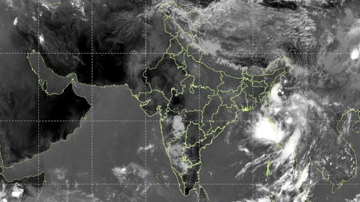
The retreat of the southwest monsoon from northwest India is becoming increasingly evident through satellite imagery. As the season transitions from abundant rainfall to drier conditions, areas in northwest and central India are witnessing a significant reduction in the thick cloud cover that previously characterised the climate. This marked change coincides with the monsoon withdrawal advancing south and east, leading to more typical post-monsoon weather patterns.

The India Meteorological Department (IMD) has reported that the withdrawal line currently extends through several locations, including Gurdaspur, Chandigarh, Muzaffarnagar, Aligarh, Dholpur, Udaipur, Deesa, and Naliya, before reaching the Arabian Sea. The monsoon’s retreat from west Rajasthan began around September 19, with Delhi experiencing the cessation of the monsoon season on September 23, ahead of its usual end date of September 25.

The IMD’s criteria for determining the withdrawal of the monsoon are comprehensive. It involves evaluating factors such as a consistent break in rainfall, changes in lower-level wind patterns, and a notable decrease in atmospheric moisture levels. These metrics confirm that the monsoon season is officially concluding in various regions.

Variable Weather Patterns Across the Country

The latest satellite images indicate extensive areas of the subcontinent are now devoid of monsoon cloudiness. Much of northwest India is experiencing considerably less cloud cover, in stark contrast to the recent episodes of rain. However, eastern and southern regions of India continue to witness cloud activity, suggesting that the transition is not occurring uniformly across the country.

Despite the waning influence of the monsoon in the northwest, the IMD has reported that it still persists in several areas. Their most recent update does not issue any weather warnings for Haryana, Chandigarh, or Delhi through October 4, indicating a relatively stable weather situation for the time being. This distinction highlights the varied impact of the monsoon’s withdrawal across different parts of India.

The presence of monsoon conditions in certain regions illustrates that the season has not yet entirely left the country, even as it weakens in the northwest. The retention of clouds and humidity in other areas indicates that the seasonal transition is ongoing and multifaceted.

Future Expectations for the Monsoon Withdrawal

The complete withdrawal of the southwest monsoon from India is a gradual process. According to the IMD, this progression is monitored by assessing the consistency of the retreat, decreasing moisture levels, and the persistence of dry weather patterns. Additionally, full withdrawal is generally expected after October 1, as the overall atmospheric circulation shifts away from the prevailing southwesterly winds.

As the skies over northwest India begin to reflect less monsoon influence, the broader context indicates that the season has not entirely concluded in other parts of the country. Satellite imagery is a valuable tool for assessing this transition, showing that while the retreat is underway, the monsoon still persists in multiple areas.

Ultimately, current satellite observations reveal that the seasonal retreat of the monsoon is well established. However, with its effects lingering in various regions, the process remains dynamic, underscoring the complexity of India’s monsoon patterns.

Long or Short, get news the way you like. No ads. No redirections. Download Newspin and Stay Alert, The CSR Journal Mobile app, for fast, crisp, clean updates!

App Store –  https://apps.apple.com/in/app/newspin/id6746449540 

Google Play Store – https://play.google.com/store/apps/details?id=com.inventifweb.newspin&pcampaignid=web_share

Latest News

Popular Videos
