


India Formalises Gogra, Hot Spring And Other Areas On Official Map To Address Border Conflicts
The CSR Journal Magazine

India has formally identified several locations in Ladakh to affirm its territorial integrity against external claims, particularly from China. The government, in collaboration with the Union Territory administration, has selected 28 significant geographical features to be included on the official map published by the Survey of India. This step aims to eliminate any confusion regarding India’s ownership of these areas, including peaks, mountains, passes, glaciers, and water bodies that share borders with China.

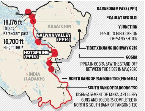
The identified places include an array of geographical features, such as ten peaks, three mountains, seven land areas, two glaciers, two passes, one river, one lake, one water body, and one valley. Notably, both Gogra and Hot Spring were central to tensions during the 2020 military standoff between India and China.

The Home Ministry stated that this official recognition of the locations is intended for better awareness and understanding among citizens regarding these integral parts of India’s territory. The administration emphasised the importance of promoting accurate recognition of these places within the broader context of national integrity.

Details of the Newly Identified Locations

The list of 28 identified places features a variety of names that reflect the rich cultural and geographical diversity of the region. Some key highlights include renowned peaks such as Kanishka Peak, Zorawar Peak, and notable passes like Chapchingal Pass and Shachmirik Pass. The inclusion of these names signifies a strategic move to ensure these areas are accurately represented and understood by the populace.

In addition to the aforementioned places, other locations comprise Alisha Giri, Martand Giri, and Shkorga Valley, among others. The geographical features chosen for inclusion serve not only as points of interest but also as symbols of India’s claims to certain contested areas that form part of the larger landscape in Ladakh.

This latest development follows a similar exercise undertaken just a few months prior, where 27 border areas and passes in Arunachal Pradesh were also formally recognised on the official map. This move is viewed as part of an ongoing effort by the Indian government to assert its territorial claims amid persistent disputes with neighbouring countries.

Context of Ongoing Border Disputes

The backdrop of these assertions involves ongoing border disputes between India and China, with both nations frequently contesting claims to various areas. China has consistently maintained its stance on certain regions in Ladakh and Arunachal Pradesh, even going so far as to assign Chinese names to these locations, which has been met with strong objections from the Indian government.

India’s recent initiatives in formally identifying these locations are aimed at reinforcing its claims against what it perceives as unfounded assertions by China. This strategy not only seeks to encapsulate the geographical details more accurately but is also indicative of India’s resolve to safeguard its sovereignty in a highly sensitive border region.

The government’s efforts to clarify territorial claims illustrate a determined approach to enhancing public awareness of the geopolitical situation surrounding India’s borders. By formally listing these areas, the administration seeks to bolster national consciousness regarding sovereignty issues that significantly affect national security and regional stability.

Long or Short, get news the way you like. No ads. No redirections. Download Newspin and Stay Alert, The CSR Journal Mobile app, for fast, crisp, clean updates!

App Store –  https://apps.apple.com/in/app/newspin/id6746449540 

Google Play Store – https://play.google.com/store/apps/details?id=com.inventifweb.newspin&pcampaignid=web_share

Latest News

Popular Videos
