


Satellite Images Show Significant Weather Shift Over India
The CSR Journal Magazine

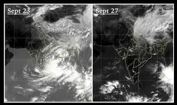
Recent satellite imagery has highlighted a significant change in weather patterns across India. As the southwest monsoon withdraws from the region, a Western Disturbance is sweeping through northern India. Captured by India’s INSAT-3DS satellite, images taken on September 23 and September 27 indicate this transition, prominently featuring the new cloud formations across the Indian subcontinent.

The satellite image from September 23 displays extensive cloud cover across northern and northeastern India, suggesting active monsoon conditions. However, the subsequent image from September 27 illustrates a notable reduction in cloud density, particularly in northwestern and central India, which appears clearer. This shift is integral to understanding the seasonal transition from monsoon to post-monsoon weather patterns.

A Western Disturbance is defined as an eastward-moving weather system originating from the Mediterranean area. Its impact can lead to the formation of clouds, rainfall, and thunderstorms in northern India, especially when it interacts with other weather systems. In this case, the Western Disturbance has notably coincided with a depression located over central India, contributing to rainfall in parts of Uttar Pradesh, Uttarakhand, and the Delhi-NCR region.

Monsoon Withdrawal Progresses Through India

The southwest monsoon has initiated its withdrawal from various areas in northwest India, with the process expected to advance towards central and eastern parts of the country. As the month of September draws to a close, rainfall activity is anticipated to diminish in many regions, with September 29 emerging as a likely turning point in the transition to drier weather conditions.

The full withdrawal of the monsoon is characterised by several climatic indicators rather than a specific date. The India Meteorological Department (IMD) considers factors such as the cessation of rainfall, reduced atmospheric moisture, and alterations in wind circulation when determining the final stages of monsoon withdrawal. This detailed analysis underscores the complexity of the weather patterns in India.

Even after the monsoon has officially withdrawn, localised weather systems may still instigate rainfall, particularly in southern and eastern India. Thus, while the overall pattern indicates a move towards drier weather, isolated weather events may still occur, bringing unexpected rain to certain regions.

Seasonal Transition Towards Cooler Months

The satellite imagery serves as visual evidence of the seasonal shift as India moves from a four-month period of monsoon activity towards the cooler months ahead. The transition encapsulates a significant adjustment in both climate and weather, as the varying atmospheric conditions will likely affect agriculture and local economies in profound ways.

As the nation prepares for this shift, attention will be focused on how regional weather patterns evolve over the coming weeks. With the transition from the monsoons often leading to a variety of climatic phenomena, continued observation and analysis will be vital for understanding upcoming weather trends.

In conclusion, the recent satellite observations mark a pivotal moment in India’s climate dynamics. As the weather evolves, both the current state and future predictions will be crucial for farmers, policymakers, and residents alike, ensuring they are prepared for the changing conditions that lie ahead.

Long or Short, get news the way you like. No ads. No redirections. Download Newspin and Stay Alert, The CSR Journal Mobile app, for fast, crisp, clean updates!

App Store –  https://apps.apple.com/in/app/newspin/id6746449540 

Google Play Store – https://play.google.com/store/apps/details?id=com.inventifweb.newspin&pcampaignid=web_share

Latest News

Popular Videos
