


Satellite Imagery Shows Enhanced Monsoon Cloud Cover Over India
The CSR Journal Magazine

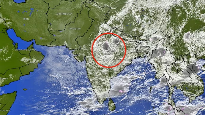
A large accumulation of monsoon clouds over several areas of India has been visually documented from space, heralding a renewed phase of rainfall, especially in the eastern and central regions of the country. The thermal infrared image provided by the INSAT-3DS satellite reveals a substantial expanse of cloud cover that ranges across central India, the Indo-Gangetic plains, and the eastern states.

Distinctive and compact cloud patterns tied to deep convection are prominently visible, suggesting the presence of active weather systems that could lead to showers and thunderstorms. Meteorologists are observing these developments closely, as they could significantly impact local weather conditions.

Regional Variations in Rainfall Predictions

While forecasts suggest that eastern India is expected to experience continued rainfall activity in the forthcoming days, other areas such as Northwest India, western regions, and much of southern India may see a notable lack of precipitation. This uneven distribution of rain underscores the fluctuating behaviour of the monsoon system, with moisture becoming increasingly concentrated in certain areas.

The satellite imagery indicates an extensive band of clouds stretching from central India towards Bihar, Jharkhand, West Bengal, and the northeastern states. Furthermore, cloud formations have been detected over parts of Madhya Pradesh and adjacent areas. This activity could potentially enhance rainfall as various weather systems interact with the overall monsoon circulation.

Weather forecasts predict that the active phase affecting eastern India will persist until the middle of September. During this time, several bouts of moderate to heavy rain may impact different regions in Eastern India. The intensity and movement of low-pressure systems, alongside other atmospheric factors, are likely to determine the exact nature of rainfall.

Localized Rainfall Expected in Delhi-NCR

In the National Capital Region, residents can anticipate a new spell of scattered rainfall. The formation of clouds and convective activity during the daytime hours could result in isolated instances of showers and thunderstorms between late afternoon and evening. Such rainfall occurrences tend to be highly localised, meaning some areas may experience significant downpours while neighbouring regions remain largely dry.

Concurrently, drier weather conditions are projected to prevail across parts of Northwest, West, and South India, contrasting with the increased precipitation likely to be observed in eastern states. This divergence in weather patterns illustrates the complexities and challenges of forecasting during the monsoon season.

The recent satellite observations paint a vivid picture of the ongoing monsoon dynamics in India. While substantial cloud clusters continue to assemble over the eastern half of the country, rainfall distribution appears to be increasingly imbalanced, setting the stage for pronounced rainfall in certain areas while leaving other regions relatively undisturbed.

Long or Short, get news the way you like. No ads. No redirections. Download Newspin and Stay Alert, The CSR Journal Mobile app, for fast, crisp, clean updates!

App Store –  https://apps.apple.com/in/app/newspin/id6746449540 

Google Play Store – https://play.google.com/store/apps/details?id=com.inventifweb.newspin&pcampaignid=web_share

Latest News

Popular Videos
