


Satellite Captures Super El Nino Powering Massive Storms in Pacific Ocean
The CSR Journal Magazine

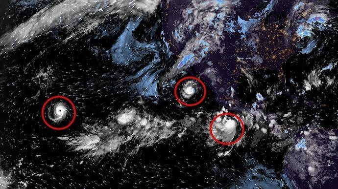
The Pacific Ocean is currently experiencing an extraordinary surge of tropical activity, as evidenced by a recent satellite image. This imagery showcases three significant storm systems swirling over the ocean as the influence of El Nino persists. Notably, there are two well-defined cyclonic formations alongside another developing storm system in the eastern and central Pacific regions.

The concentration of these systems emphasizes the Pacific’s emergence as a hotspot for tropical disturbances. Among these, Hurricane Polo stands out; it has weakened to a Category 3 storm but still represents a considerable threat to Mexico’s Baja California peninsula. As of Sunday evening, the US National Hurricane Centre reported that Polo was located approximately 200 miles (320 km) off the Baja California coast, moving north-northwest at a speed of 12 mph (19 km/h).

Impending Landfall of Hurricane Polo

Forecasters are predicting sustained wind speeds of between 60 and 80 mph (100 to 130 km/h) in the area where the storm is projected to make landfall. In addition, there is a significant risk of flooding and mudslides in vulnerable regions, prompting local authorities to prepare for potential emergencies.

The aftermath of Hurricane Polo could lead to considerable disruption, particularly with rain estimates suggesting between 4 to 8 inches could fall across Baja California, and isolated amounts could reach up to 12 inches in Baja California Sur. Such rainfall could trigger life-threatening flash floods and mudslides, necessitating evacuations in at-risk communities.

El Nino’s Role in Storm Development

The current tropical activity is occurring within the context of El Nino, a climate phenomenon known for causing unusually warm sea surface temperatures in the central and eastern equatorial Pacific. This warming can significantly influence atmospheric circulation, altering wind patterns and ocean temperatures, which in turn favours the formation of tropical cyclones in various parts of the Pacific region.

Nonetheless, the evolution and intensity of individual storms are influenced by a variety of additional factors, including atmospheric moisture levels, wind shear conditions, and local oceanographic circumstances. This complexity underscores the challenges meteorologists face when predicting storm development and trajectory.

Currently, there is a new tropical depression manifesting in the wake of Hurricane Polo, alongside another disturbance anticipated to arise southeast of Hurricane Nolo and Hawaii. Collectively, these systems convey the scale of tropical activity occurring in the eastern and central Pacific, which remains under continual observation by meteorologists as they assess potential impacts on coastal communities.

Long or Short, get news the way you like. No ads. No redirections. Download Newspin and Stay Alert, The CSR Journal Mobile app, for fast, crisp, clean updates!

App Store –  https://apps.apple.com/in/app/newspin/id6746449540 

Google Play Store – https://play.google.com/store/apps/details?id=com.inventifweb.newspin&pcampaignid=web_share

Latest News

Popular Videos
