


Satellite Imagery Reveals Lack of Rain Clouds in Central India During Monsoon Peak
The CSR Journal Magazine

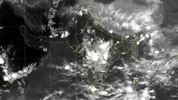
Recent satellite images from the India Meteorological Department (IMD) illustrate a significant disparity across India, showing that a substantial part of central India is notably devoid of cloud cover. This observation coincides with a robust monsoon depression that is currently producing widespread rainfall in Maharashtra and is anticipated to enhance precipitation in Gujarat.

The thermal infrared images from the INSAT-3DS satellite, taken on Friday morning, depict an extensive aggregation of dense convective clouds associated with the monsoon depression over the Vidarbha region. In contrast, vast areas of Madhya Pradesh and surrounding regions in central India present a largely clear sky.

Meteorologists explain that this phenomenon is typical for a mature monsoon depression, where the most severe thunderstorms and rainfall are centralised around the core of the weather system, as well as along its western and southern peripheries.

Movement and Expected Developments of the Depression

According to reports from the IMD, the depression located over eastern Vidarbha and adjoining regions of west-central Chhattisgarh has been progressing westward at an approximate speed of 15 kmph over the last six hours. By 5:30 am IST on July 31, it was situated in central Vidarbha and nearby southern Madhya Pradesh.

The system was identified about 30 km north of Wardha, 60 km west-southwest of Nagpur, 90 km east of Amravati, 130 km south-southeast of Betul, and 160 km east of Akola. The weather pattern is projected to continue its west-northwest trajectory across Vidarbha and southern Madhya Pradesh over the next 24 hours, drawing substantial moisture from the Arabian Sea inland.

Current satellite images depict towering thunderclouds looming over eastern Maharashtra, extending into Gujarat. This indicates the potential for intense rainfall, which could lead to flash floods, urban flooding, and waterlogging in affected areas.

Forecast for Future Rainfall Across Regions

Despite the relative scarcity of cloud cover in certain regions of central India, meteorological experts assert that this does not signify a cessation of monsoon activity. Rainfall patterns are projected to shift westward in tandem with the depression’s movement, resulting in new instances of heavy rain in areas directly impacted by the system.

Overall, the depression is set to remain a prominent feature affecting the weather in central India throughout the weekend, maintaining active monsoon conditions across western India while helping to redistribute rainfall after a period marked by uneven monsoonal activity across the nation.

Long or Short, get news the way you like. No ads. No redirections. Download Newspin and Stay Alert, The CSR Journal Mobile app, for fast, crisp, clean updates!

App Store –  https://apps.apple.com/in/app/newspin/id6746449540 

Google Play Store – https://play.google.com/store/apps/details?id=com.inventifweb.newspin&pcampaignid=web_share

Latest News

Popular Videos
