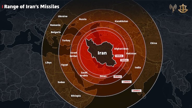
The Israeli military has issued a public apology after sharing a map on social media that incorrectly depicted Jammu and Kashmir as part of Pakistan, leading to a massive backlash from Indian users online. The controversial map was posted by the Israel Defence Forces (IDF) on their official X (formerly Twitter) handle on Friday night. The map, intended to illustrate the range of Iranian missiles amid escalating conflict between Israel and Iran, also misrepresented India’s northeastern states as part of Nepal.
Iran is a global threat.
Israel is not the end goal, it’s only the beginning. We had no other choice but to act. pic.twitter.com/PDEaaixA3c
— Israel Defense Forces (@IDF) June 13, 2025
The error was quickly noticed and widely condemned by Indian netizens, many of whom tagged Israeli Prime Minister Benjamin Netanyahu and demanded immediate correction. Within 90 minutes of the initial post, the IDF responded directly to one of the critical tweets, stating, “This post is an illustration of the region. This map fails to precisely depict borders. We apologise for any offence caused by this image”. The IDF clarified that the map was not meant to be an official representation of geopolitical boundaries, but the apology did little to quell the anger of many Indians, who saw the error as unacceptable from a close strategic ally.
The incident occurred at a sensitive time, as Israel and Iran exchanged military strikes, and the IDF was highlighting Iran as a “global threat”. The controversial map showed concentric circles radiating from Iran, marking the range of its missiles, and included India within that range. However, the depiction of Jammu and Kashmir as part of Pakistan, and the misplacement of northeastern states, struck a nerve with Indian citizens who are deeply sensitive about the country’s territorial integrity.
Now you understand why India remains neutral. In diplomacy, no one’s really your friend.
— Indian Right Wing Community (@indianrightwing) June 13, 2025


