


Delhi-NCR Faces Heavy Rainfall and Thunderstorms Driven by Weather Systems
The CSR Journal Magazine

Delhi-NCR faced severe weather conditions on Monday, marked by heavy rainfall and thunderstorms, following gusty winds and initial showers that began late on Sunday night. The areas of Delhi, Gurugram, Noida, Faridabad, and Ghaziabad reported a significant change in weather, with expectations of further thundershowers in various locations. Safdarjung, the primary weather observatory in Delhi, noted approximately 40 mm of rainfall recorded by 5.30 am.

The India Meteorological Department (IMD) had issued warnings for heavy rain and thunderstorms across parts of northwest India, despite the southwest monsoon having retreated from multiple regions. The unexpected intensity of the rainfall has prompted authorities to prepare for potential challenges related to traffic and urban water drainage.

Satellite Imagery Highlights Weather Developments

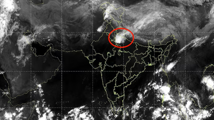
The INSAT-3DS thermal infrared image, taken between 8.30 am and 8.57 am on Monday, revealed extensive cloud cover over northern India. The image displayed a broad cloud band encompassing parts of the Himalayan region and adjacent plains. Areas depicted in brighter white generally indicate colder cloud-top temperatures, which are typically associated with large, deep clouds capable of generating thunderstorms. However, this image cannot independently verify rainfall intensity at specific sites.

The prevailing cloud patterns correspond with an active weather system affecting northwest India, with rain-bearing cloud bands stretching toward the Delhi-NCR area. Observations from this satellite imagery suggest that considerable atmospheric activity is in place, contributing to the current weather conditions.

Western Disturbance Plays a Key Role

A Western Disturbance is identified as the main driver of this precipitation event. This weather system, which moves eastward from the western regions, brings rain, thunderstorms, and occasionally hail to northwestern India. An October 11 bulletin from the IMD indicated the presence of a Western Disturbance as a cyclonic circulation situated over Himachal Pradesh.

Moreover, additional atmospheric troughs extending from northwest Rajasthan toward northeast Madhya Pradesh, along with another connecting a circulation over central Pakistan with northern Madhya Pradesh, are reinforcing the weather pattern. These atmospheric systems can create conditions conducive to upward air movement, leading to cloud formation when adequate moisture and instability are present.

Fresh cloud bands sweeping in from central Haryana are augmenting the ongoing showers across the plains. As these bands progress through the region, varying segments of Delhi, Gurugram, Noida, Faridabad, and Ghaziabad may witness alternating spells of moderate to heavy rain accompanied by thunderstorms.

Expectations for Continued Rainfall

The IMD has issued a warning for continued heavy rain, thunderstorms, and gusty winds affecting Delhi on Monday morning. Orange alerts were also communicated for several adjoining districts in Haryana and Uttar Pradesh. Such rainfall events have the potential to lead to waterlogging, traffic disruptions, and decreased visibility for commuters.

This weather occurrence underscores a critical point: the withdrawal of the monsoon does not signal an end to precipitation in the region. Weather systems such as Western Disturbances can lead to substantial rainfall even after the seasonal monsoon has receded. Currently, the rain affecting Delhi-NCR arises from these post-monsoon atmospheric disturbances, rather than a resurgence of the southwest monsoon.

Long or Short, get news the way you like. No ads. No redirections. Download Newspin and Stay Alert, The CSR Journal Mobile app, for fast, crisp, clean updates!

App Store –  https://apps.apple.com/in/app/newspin/id6746449540 

Google Play Store – https://play.google.com/store/apps/details?id=com.inventifweb.newspin&pcampaignid=web_share

Latest News

Popular Videos
