


Two Satellite Images Document Cyclone Arnab’s Progress Across India
The CSR Journal Magazine

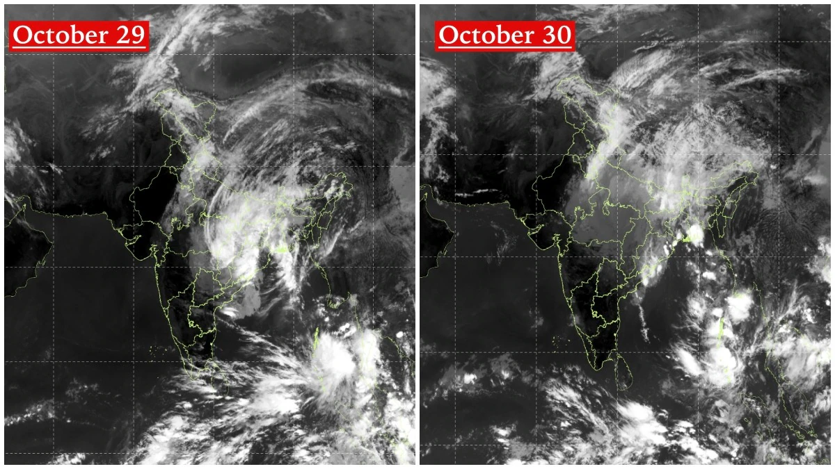
Two satellite images taken by India’s INSAT-3DS satellite on October 29 and 30 illustrate Cyclone Arnab’s journey as it moved northward across eastern and central India. Initially classified as a Very Severe Cyclonic Storm, Arnab has significantly weakened after making landfall from the Bay of Bengal. The India Meteorological Department (IMD) has reported that the cyclone’s remnants have transitioned into a well-marked low-pressure area located over central Chhattisgarh and adjoining Odisha.

The first image, captured on October 29, reveals a large, organised mass of dense clouds spreading across eastern and central India. The cloud bands from the cyclone extend towards the northeastern parts of the country, with particularly dense formations observed over Odisha, Chhattisgarh, Jharkhand, and West Bengal. This visual representation highlights the cyclone’s extensive reach before it began to weaken.

Weakening of Cyclone Arnab

By October 30, the satellite imagery indicated that the cloud mass continued its northward trajectory, although the system’s circulation appeared less organised. The cloud cover remained widespread across eastern and northeastern India, but the structure had become more diffuse compared to the previous day’s observation. This change aligns with the IMD’s assessment issued at 9:15 pm on October 29, which noted the cyclone’s transition into a low-pressure area.

According to the IMD, the depression, which is the remnant of Cyclone Arnab, moved nearly northwards and weakened into a well-marked low-pressure area at 5:30 pm on October 29. The IMD anticipates that the system will continue its north-northeastward movement and further weaken into a low-pressure area over northeast Chhattisgarh and its surrounding regions within the next 24 hours.

This transformation from a very severe cyclone to a low-pressure area marks a significant change in Arnab’s status. As the system progressed inland, it encountered conditions that diminished its circulation and reduced its capacity to sustain strong winds. However, this weakening does not entirely eliminate the weather threat, as the remnant circulation and associated moisture may still lead to rainfall and thunderstorms across parts of eastern and central India.

New Weather System Developing Over Andaman Sea

The satellite image from October 30 also reveals a separate area of intense cloud activity over the South Andaman Sea and adjacent regions. The IMD has classified this as a low-pressure area, referred to as system A in its latest weather bulletin, while the remnants of Arnab are being monitored as system B. This development is significant, as atmospheric conditions over the Bay of Bengal remain active.

These two satellite images together illustrate the evolving weather landscape across the Indian subcontinent. One cyclone is nearing the end of its journey as it weakens over land, while another area of disturbed weather is emerging over the Andaman Sea. For meteorologists, the focus is now shifting from tracking the intensity of Cyclone Arnab to monitoring its rainfall impacts and the potential development of the new system over the Bay of Bengal.

The ongoing situation underscores the dynamic nature of weather patterns in the region, highlighting the necessity for continuous observation and analysis. As both systems evolve, updates from the IMD will be crucial for assessing potential impacts on the affected areas.

Long or Short, get news the way you like. No ads. No redirections. Download Newspin and Stay Alert, The CSR Journal Mobile app, for fast, crisp, clean updates!

App Store – https://apps.apple.com/in/app/newspin/id6746449540

Google Play Store – https://play.google.com/store/apps/details?id=com.inventifweb.newspin&pcampaignid=web_share

Latest News

Popular Videos
